Malgré-Nous

French men and women in the German Wehrmacht and Waffen-SS during the Second World War

by Arthur Koehl

Sources of the data analyzed

Our major sources of data are the databases that were set by the mission "Memory" of the region "Grand Est" of France 1. Those databases contain the names and biography of the Alsatian victims during the second World War, including those that were enrolled against their will in the German Armies (the Malgré Nous), civilians that died during bombardments, resistants, victims of deportation, .... We have selected those that fall into the first category, from the Western Archives section of the Memoires. 2 This database was generated based on original documents from:

When we collected the information (November 2016), the database contained information about 23,623 Malgré Nous.

As mentioned on the portal to the database, the information provided may be incomplete, imprecise, and some times contradictory. When possible, we have tried to correct mistakes (such as names of places misspelled or misplaced), but only when the correction was unambiguous.

Geocoding the different locations

Most of the records from the Malgré Nous described above contain information on the place of birth and place of disparition, provided as the name of a city and of the corresponding country. As mentioned above, there are some inconsistencies in those information. Some of those inconsistencies are simply a consequence of changes of border lines after the War. Some are related to spelling of names, changes in the name of the city (for example, the free city of Danzig in Germany is now Gdansk in Poland); we corrected those manually. Inconsistencies that could not be resoled lead to the corresponding data to be ignored.

Once we had all the place information cleaned up, we proceeded by converting those names into longitude and latitude, a process referred to as geocoding. We used the Python library geocoder 3 for this task, binding the corresponding code to ArcGis. The script we used is provided here.

From latitude-longitude to positions on images of maps

The maps used to present the locations of disparition of the Malgré Nous during the second World War are extracted from the "Atlas of the World Battle Fronts in Semimonthly phases to August 15 1945". This Atlas was produced for the Chief of Staff of the United States Army in 1945 4.

In this Atlas, the maps used for presenting the war against Germany through November 1944 are based on azimuthal equidistant projection. In this projection, curving latitudes and converging longitudes appear somewhat as they do on a sphere. The maps are drawn such that Berlin corresponds to the origin. The last six months of the war in Europe are shown on enlarged maps with a change of scale from about 250 to 125 miles to the inch.

Consider a location given by its latitude φ and longitude λ. To find its corresponding position (xp, yp) on the image representing a map (where xp and yp are pixel locations), we proceed in two steps:

  1. Find the plane coordinates (x,y) obtained from the azimuthal equidistant projection
  2. Transform the coordinates (x,y) into the pixel coordinates (xp, yp).

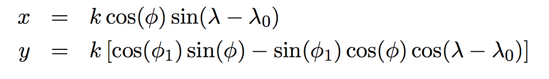
Step 1: the azimuthal equidistant projection

Let φ1 and λ0 be the latitude and longitude of the center of the projection, respectively. For the maps considered, (φ10)=(52.52,13.4), i.e. the latitude and longitude of Berlin. Let φ and λ be the latitude and longitude of a point on the sphere representing the Earth. The transformation equations for the azimuthal equidistant projection are given by 5:

with:

and

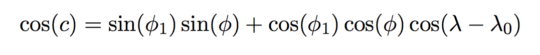
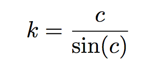
where c is the angular distance to the center of the projection.

Step 2: Positioning on the maps

The projection described above gives coordinates (x,y) is arbitrary units. To locate those coordinates on the image of a map, we apply linear transformations, namely a scaling and a translation. As such,

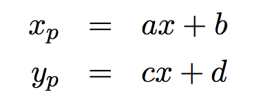
The coefficients a, b, c, and d are computed independently for each maps considered. We select two locations (we chose Milan and Minsk). For those two locations, we know their latitudes and longitudes and therefore the corresponding coordinates (x,y). We also find manually their pixel coordinates (xp,yp) for a given map. The coefficients a, b, c, and d are then computed to have the pixel coordinates fit with the planar coordinates, according to the equations above.


Continue to the next section: Resources for Research


Notes

  1. "Victimes alsaciennes de la Second Guerre Mondiale" (French: Alsatian victims of the second World War), maintained by the Region Grand Est, France.
  2. Archives Occidentales(French: Western archives), from the Region Grand Est, France.
  3. The Geocoder Python library
  4. Atlas of the World Battle Fronts in Semimonthly Phases to August 15 1945.
  5. Azimuthal Equidistant Projection, Wolfram MathWorld.